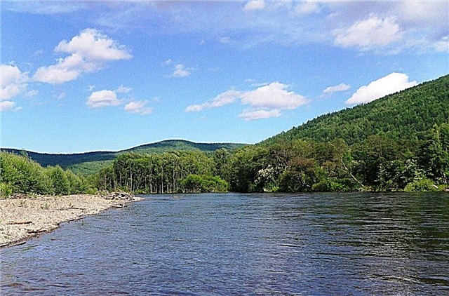
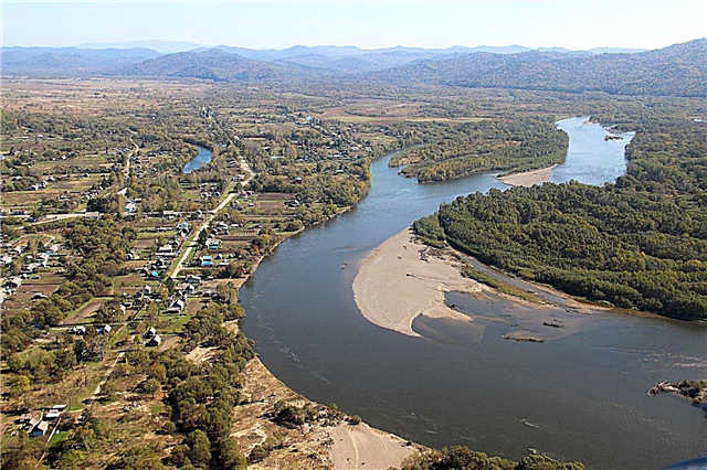
The river network of Primorsky Krai is well developed, but it is uneven. Rivers that have their source on the ridges of the Sikhote-Alin mountain range are more extended and have a calm flow. The rivers that flow into the Sea of Japan are small, rapids and fast flowing. The water content of the rivers of the Primorsky Territory can change dramatically during the year, floods and floods are frequent. In total, there are about 60,000 rivers in the Primorsky Territory. Their total length is over 140,000 km.
The nature and landscapes of the river banks are beautiful and attract travelers. The natural wealth of the river valleys was appreciated not only by tourists. Several natural areas are protected by the state as nature reserves, there are places protected by the world organization UNESCO. Fishing is one of the main activities in the taiga rivers of the region. There are fascinating rafting routes on many rivers.
The longest rivers of Primorsky Krai
List of the largest rivers flowing through the region.
Ussuri
It flows through the Khabarovsk and Primorsky Territories, as well as through the Heilongjiang Province in the PRC. The character of the river is predominantly flat, except for the section passing through the Sikhote-Alin mountains. Travelers often come to the banks of the Ussuri to relax by the water in peace and tranquility. Against the backdrop of picturesque nature, you can take spectacular photos during hiking or boat trips.
The total length of the river is 897 km.

Foggy
It flows in the Primorsky Territory of Russia, along the Jirin provinces in the PRC and Yangando in the DPRK and is of great strategic importance. The only bridge across Tumannaya between Russia and the DPRK is the railway "Friendship Bridge". On the territory of Russia and before it flows into the Sea of Japan, the river has a slow flow. Foggy is popular among fans of fishing and sport hunting for waterfowl.
The length of the river is 549 km, in the Primorsky Territory - 17 km.

Bikin
In the lower reaches of the Bikin, there is an array of cedar-deciduous forests. This untouched piece of forest with an area of over 4,000 km² is called the Bikin River Valley and is protected by UNESCO. Small indigenous peoples live here - the Udege. Many rare species of animals and birds live - the Japanese crane, the Amur tiger. Bikin flows through the Primorsky and Khabarovsk territories.
The total length of the river is 560 km.

Bolshaya Ussurka
In the upper reaches, the banks of the river are steep and steep, the bottom is rocky. There are rapids, rifts and steep bends in the channel. The lower course of the river is more suitable for rafting. Here, the height of the banks does not exceed two meters, the bottom of the river becomes sandy. In the lower reaches, rafting is possible not only on rafts or kayaks, but also on inflatable rafts. The width of Bolshaya Ussurka is 80-100 meters, during the flood period it reaches 300 meters.
The length of the river is 440 km.

Arsenyevka
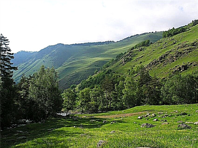
The sources of the river are located at an altitude of more than 100 meters above sea level, then it flows along the intermontane hill among the taiga coniferous forest. The picturesque banks of the river attract not only fishermen and hunters here. You can appreciate the beauty of nature on a water trip. Rafting on Arsenyevka is not difficult. But it is worth considering the peculiarities of the river - steep banks and many bends.
The length of the river is 294 km.

Malinovka (tributary of the Bolshoi Ussurka)
Previously, it was called Iman, which in ancient Manchu means "mountain goat". The nature of the river banks is varied. There are spruce, larch, and cedar forests, as well as small areas of birch forest. The winding river bed forms loops. The length of the islands in the channels reaches 3 km. The bottom of the river is sandy and pebble. The average depth of Robinovka is 2 meters, in some places it reaches 4 meters.
The length of the river is 274 km.

Razdolnaya
It flows in the Heilongjiang province in the PRC and along the Primorsky Territory in Russia. On the territory of Russia, it has a calm current and a flat character. Gentle shores occasionally give way to rocky cliffs covered with dense forest. In the lower reaches, the river bed becomes winding and branched. The river is inhabited by carp, crucian carp, catfish. In winter, smelt, flounder and navaga are well caught.
The length of the river is 245 km, in the Primorsky Territory - 191 km.

Muddy
The former name of the river is Lefu. The source of the river is located on one of the slopes of the Przhevalsky ridge of the Sikhote-Alin mountain range. The mountainous part of the river is covered with dense forest, while the plain is covered with meadows. The width of the river varies from 34-40 meters in the lower reaches to 50-70 meters in the upper reaches. The river bed is meandering. Fishing is the most popular recreation on the Ilistaya River. It contains grayling, Dolly Varden char, taimen, pike, lenok.
The length of the river is 220 km.

Samarga
The banks of the river are difficult to reach. The river is located far from large settlements. There are only two villages on its banks - Samarga and Azgu. At the same time, Azgu is the northernmost settlement of the Primorsky Territory. You can get here by helicopter or by water along the river. The untouched nature around the river is diverse. In the upper reaches of the Samarga spruce and fir grow, in the lower reaches - oaks and birches.
The length of the river is 218 km.

Sungacha
The border river flows between Heilongjiang Province in the PRC and the Primorsky Territory in Russia. China owns the left bank of the Sungachi. In Russia, it flows through the territory of the Khankaisky nature reserve. In the valley of the river there are many small lakes, near which the relict plant Nut-bearing Lotus, included in the Red Book, grows. The width of the river is from 30 to 60 meters, the depth is 3-3.5 meters.
The length of the river is 210 km.

Marevka
A large tributary of the Bolshoi Ussurka. The source of the river is in the Sikhote-Alin mountain ranges. For the first few kilometers, it flows through a narrow valley with rocky high banks. The width of the river in the valley is 2-3 meters, the current is fast. Further, the Marevka will expand to 16 meters, the speed of the current slows down to 0.3 m / s. The banks are covered with forests or waterlogged. The depth of Marevka is on average 1-2 meters.
The length of the river is 179 km.

Alchan (tributary of the Bikin)
It begins on the slopes of the Sikhote-Alin mountain system. Most of the river basin is covered with forest. The species of trees in it are varied - cedar, birch, oak, spruce and Manchurian walnut. The river basin includes several hundred small rivers and streams. The largest are the rivers Levaya, Pravaya, Shirokaya and Ulitka. Abundant summer rains often cause floods, and large floods occur every few years.
The length of the river is 170 km.

Armu
It flows through the territory of the Krasnoarmeisky District National Park, where it flows into the Bolshaya Ussurka River. There are no settlements on the river. The closest to the river is the village of Dersu, 14 km away. The roads in this area are in poor condition and are mostly logging. Nevertheless, the river is used for rafting; it is along it that the most famous rafting route in Primorye passes.
The length of the river is 168 km.

Komissarovka
Previously, Komissarovka was named Pencha and Sintuhe. The source of the river is located on one of the slopes of the Pogranichny Range. The first 25 km of the river has a mountainous character, then it is flat. The bottom of the river is sandy and has pebble areas. The depth in the reaches is about 2 meters, on the rifts - no more than 0.5 meters. The river is 45 meters wide. Several villages and railway stations are located on the banks of the river.
The length of the river is 162 km.

Partisan
The river flows along the southern side of the Primorsky Territory. The source takes in the ridges of the Sikhote-Alin mountains. Partisan flows into the Sea of Japan near the city of Nakhodka. It has a predominantly mountainous character - rifts, fast current, rocky bottom. In addition to rafting and fishing, it is popular among tourists to visit interesting sites - caves and the Chandalaz ridge. The river has several large tributaries, all of which are very picturesque.
The length of the river is 142 km.

Dalnyaya (tributary of the Bolshoi Ussurka)
Previously it was called Tachibe, in the 19th century it was known as Taijiberi. It flows through a taiga, almost uninhabited area. The banks of the river are completely covered with forest. The channel of the Dalnyaya River is winding and branched.The bottom is rocky and pebbly, the height of the steep banks is about 1.5 meters. The channel width is about 50 meters. Large tributaries are the Tigryanka and Golubitsa, over 40 km long.
The length of the river is 135 km.

Pavlovka (tributary of the Ussuri)
The source of the river is located between the peaks of the Sikhote and the Vedernaya mountains of the Sikhote-Alin. The shores are rocky. The river valley is mostly covered with forest. In the upper reaches, it is mainly coniferous or mixed forest. In the lower reaches, it is a broad-leaved forest of maples, lindens and oaks. The height of the valley slopes reaches 600 meters. Pavlovka's food is mainly rain-fed. The waters of the river are used for domestic and economic needs.
The length of the river is 132 km.

Kema
Near the village of Velikaya Kema, a small river flows into the Sea of Japan. The mouth is 50 to 70 meters wide. The banks of the river are covered with taiga forest - spruce, birch, fir, oak. Kem rafting has five difficulty levels. In rapids, competitions are often held, which gathers several hundred spectators. Several small lakes are formed in the river valley - Saturn, Eagle's Nest, Uzlovoe.
The length of the river is 119 km.

Zhuravlevka
It flows in a valley located between the mountain spurs. The valley slopes are up to 600 meters high. The dense mixed forest of the river basin is dominated by conifers. The banks of the channel are about a meter high, it practically has no tortuosity. Zhuravlevka is a great fishing spot. You can catch taimen, grayling and lenok in it. Best of all, fish are caught in the upper reaches of the river.
The length of the river is 114 km.

Edinka
The water temperature in the river is lower than in other rivers of Primorye. The average temperature in the summer months is 12 degrees. It flows through mountainous terrain among larch, fir and black birch trees. The mountains in the upper reaches of the river are up to 1600 meters high, in the lower reaches - 800 meters. The width of the valley varies along the entire length of the river and reaches 2.5 km. Floods are frequent on Edinka. In May, they are caused by melting snow, in summer - by rains.
The length of the river is 108 km.

Kievka
The source of the river is in the Sikhote-Alin mountains, the mouth is in the bay of the Sea of Okhotsk. Large tributaries of the river are Kamenka, Lazovka, Benevka, Krivaya, Perekatnaya. Their length ranges from 20 km to 71 km. There are many waterfalls and rapids in them. Fans of extreme tourism come to the threshold of the Robber. The most visited by tourists are the cascading waterfalls on the Elomovsky Key called Benev Waterfalls.
The length of the river is 105 km.

Maksimovka
When kayaking, you need to be careful - Maksimovka has a different character. In the upper reaches, it is shallow, in the lower reaches, it has rough rapids. The waters of the river are clean. In the middle reaches of the river, char and lenok are well caught, less often grayling. In the lower reaches there are kunja and taimen. There are bears and tigers in the forests on the banks of the river. There are about 1000 small rivers and streams as tributaries of Maksimovka.
The length of the river is 103 km.

Abramovka
It is a tributary of the Ilistaya River. The source is located in a hilly wetland near the village of Priluki. The former name of the river is Chikheza. The width of the river is on average 10 meters, the maximum is about 40 meters. The depth ranges from 0.8 meters to 4 meters. The area around the river is covered with shrubs and meadows, wooded areas are rare. The village of Pavlovka in the Abramovka floodplain has several lakes.
The length of the river is 102 km.

Nesterovka (tributary of the Melgunovka)
It flows into the Border Region of Primorsky Krai and Heilongjiang Province in the PRC. The source of the river is located in the East Manchurian Mountains in the PRC. The river acquires a flat character only in the lower course. In the lower reaches, its width is about 30 meters, depth - from 0.5 meters to 2 meters, on rifts - no more than 0.5 meters. The water quality in Nesterovka is deteriorating due to the activities of enterprises on its banks.
The total length of the river is 98 km.

Boar
There are no settlements on the banks of the river, and it is impossible to reach it by car. However, the river is used for sports rafting in the area between the mouth of the Dagda River and Krepostnaya Bay. The nature around the river has a taiga character. The forest mainly consists of spruce and larch mari. The inhabitants of the forest are wood grouses and elk. In the upper reaches of the river, among the mountain peaks, the Okhotnichye Lake is formed.
The length of the river is 97 km.